


RadSat HD Pro
4.2140.00 Reviews
App Specs
- Version
- 4.0.17
- Updated On
- License
- Free
- Downloads
- 100,000+
- Developer
- SocialEx Aplicaciones
- Categories
- Weather
- Platform
- Android
Screenshots
 Analysis by AppCompare
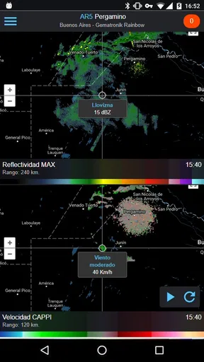
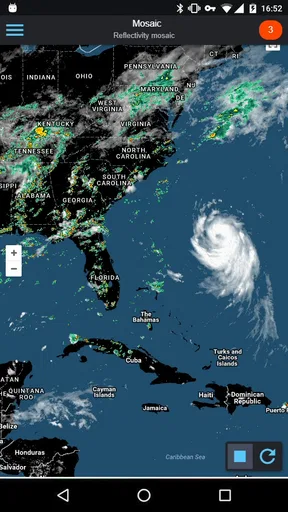
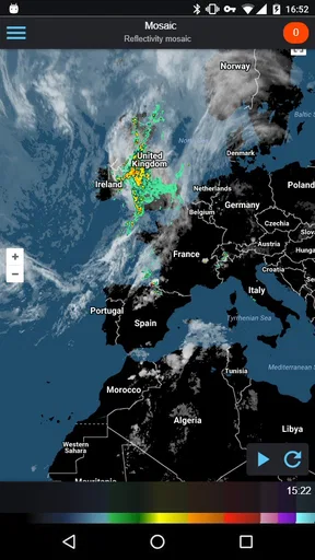
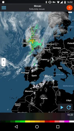
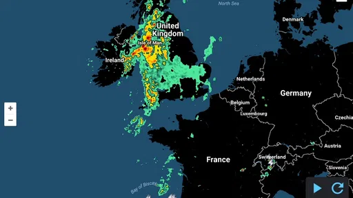
I tend to judge weather apps by what happens when the forecast is no longer a casual glance at tomorrow’s temperature. A normal forecast is fine for deciding what to wear, but a moving storm can make timing, direction, and local detail much more important. RadSat HD Pro takes that more practical approach. It is a weather app from SocialEx Aplicaciones that puts radar, satellite imagery, and lightning information on an interactive map, so I can look at the weather as something moving across a place rather than as a single static prediction.
That makes it especially interesting on a shared household device. One person may want to know whether it is safe to leave for work, another may be waiting for a school pickup, and someone else may simply want to see whether rain is approaching the neighborhood. I found the map-based view more useful for those conversations than repeatedly checking a small icon that says “rain.” The app is free, aimed at Everyone, and has built a solid audience with a 4.2 average from around 2.5 thousand ratings and over 100 thousand installs.
There is an important distinction, though. This is not the kind of weather app I would choose only for a cheerful daily forecast. Its appeal is visual monitoring. If you want a quick temperature, a simple forecast panel may feel faster. If you want to inspect the movement of weather around a household’s plans, RadSat HD Pro has a more focused reason to exist.
How it works when several people share one device
The most convincing everyday use is a shared tablet or phone kept in a kitchen, hallway, or living room. Imagine a family preparing to leave for a weekend activity. Instead of asking whether the forecast says rain, I would open the map and look at the surrounding area. The radar view can help me judge whether the weather is already nearby, whether a band of rain is moving toward us, or whether the situation looks more stable in the direction we plan to travel.
That does not turn the app into a perfect travel planner. A radar image shows what is happening across the map, not every detail of what will happen at a particular address later in the day. Still, it gives a kind of context that ordinary forecast cards often hide. In a shared setting, that context matters because different people can look at the same visual information and make a decision together.
I also like that the app’s central idea is easy to explain. A child can understand that a colored area on the map represents weather moving across a region, while an adult can use the same screen to think about timing. That makes it more approachable than a technical weather dashboard filled with unfamiliar charts. At the same time, the map can become busy, so I would not leave a young child to interpret severe-looking activity without an adult checking the situation.
For a household, the practical benefit is not that everyone gets a separate personalized forecast. The benefit is having one shared visual reference. Someone can check the map before leaving, another person can look again later, and the family can discuss the same area instead of comparing different forecast screens. This is a modest feature of the experience, but it makes the app feel more useful on a communal device than an app designed only for one person’s quick glance.
Worth Reading Before You Choose

EA SPORTS FC Mobile 26 Is a Bigger Football Game, but It Takes Time

Flipboard Shows What News Apps Must Do Beyond the Feed

Switching to Android Auto Means Rethinking Your Driving Routine

Google Calendar Makes a Crowded Week Easier to Manage

Ludo King Makes the Most of the Minutes Between Plans

Baby Panda World Brings Quick Play to Modern Phones, but Its Game Library Feels Busy
What I would check before relying on it
I would begin with the map rather than trying to understand every option at once. First, I would identify the household’s location, then zoom out enough to see the surrounding region. A map that is too tightly framed can make a weather patch look more important than it is, while a map that is too broad can hide local movement. Switching between a local view and a wider regional view is one of the most useful habits I developed with this kind of app.
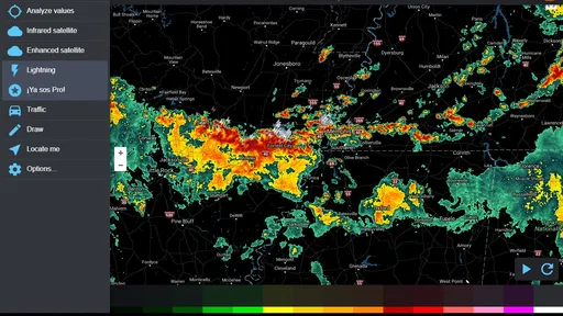
The satellite layer is valuable when I want visual context beyond the radar colors. Looking at cloud cover and the shape of the weather system can make the map easier to interpret, especially when the radar view alone feels abstract. Lightning information adds another layer for storm awareness. I would treat it as a reason to pay closer attention, not as permission to continue an outdoor plan. The app helps me observe conditions; it does not replace local warnings or sensible judgment.
One less obvious trade-off is that more information is not automatically better information. Radar, satellite imagery, and lightning activity can make a screen look impressive, but a busy map can encourage people to stare at details without asking the basic question: what decision are we trying to make? For a shared device, I would keep the workflow simple—open the map, locate the area, check the movement, and then compare that view with the planned time and activity.
Setup boundaries on a household phone or tablet
Because this is a weather tool rather than a family-management app, I would set expectations before handing it to several people. It is not a substitute for household accounts, child profiles, or a coordinated family calendar. The app’s value comes from its map and weather layers, not from separating one person’s preferences from another’s. On a shared device, that means the clearest approach is to treat it as a common reference rather than as a private personal dashboard.
That boundary is useful because it prevents a common mistake: expecting every weather app to remember and organize each family member’s needs. RadSat HD Pro is better suited to “What is happening around us?” than “What is each person’s schedule for the day?” If I needed individual notifications, detailed planning, or a family-wide system for assigning responsibilities, I would use another tool alongside it rather than trying to force this app into that role.
The age rating is Everyone, which fits the straightforward subject matter. Even so, age suitability and weather understanding are different things. A younger user may be able to operate the map but still misunderstand the seriousness of lightning or an approaching storm. I would show a child how to read the basic display, then make it clear that an adult decides whether an outdoor activity continues.
Another setup consideration is the app’s payment model. The download is free, while in-app purchases are listed at $7.99 per item. On a shared device, I would check the household’s purchase settings before letting children explore the app. I would not assume that “free” means every part of the experience is free, and I would explain to other users that any optional purchase should be discussed first. That is a small but important boundary when several people use the same device.
The current version is 4.0.17, and the app can run on an operating system as old as version 3.0. That broad compatibility may make it useful on an older spare phone or tablet that a household keeps in a common area. The trade-off is that an older device may not feel as smooth when handling animated map imagery. I would test the map on the actual shared device before deciding that it is ideal for a permanent kitchen display.
A practical routine for shared use
My preferred routine would be short and repeatable. Before an outing, one person checks the local map, then zooms out to see whether the weather system is approaching from a wider area. If lightning activity is visible, I would treat that as a prompt to pause and consult official warnings or reconsider the plan. Later, another household member can repeat the check rather than relying on an earlier glance.
This routine avoids overconfidence. A colorful map can look precise, but weather changes and visual layers require interpretation. I would also avoid using a single screenshot as proof that conditions will remain safe. The app is most useful when checked at sensible intervals and combined with the actual conditions outside.
For a household with an older relative, the visual map can be easier to discuss than a technical forecast full of percentages. I could point to the area of interest and explain what I am seeing. However, if someone needs highly specific accessibility features or very large text, I would evaluate the device and operating system separately rather than assuming the map will suit everyone equally.
Coordination without turning the app into a control center
RadSat HD Pro works well as a conversation starter. If one person is driving and another is checking the weather, the map can help answer practical questions such as whether to leave now, wait a little, or choose an alternative route. It is particularly helpful when the weather is uneven across nearby areas. A standard forecast for one location may not show why conditions look different a short distance away, while the map gives that regional perspective.
I would not use it as the only basis for emergency coordination. The app can show weather information, but a household still needs a separate way to communicate, and official alerts remain important for urgent situations. This distinction is one of the most important limits to understand: visual awareness is not the same as an emergency notification system.
The lightning layer changes how I think about outdoor plans. Rain alone may lead to a decision about umbrellas or clothing, while lightning changes the safety discussion. In a family setting, that makes the app useful for teaching a simple rule: a weather map is not entertainment when storm activity is nearby. I would use the screen to support a decision already guided by caution, not to search for a reason to continue.
There is also a useful division of labor. A teenager might check the map before cycling home, an adult might review it before driving, and another person might use the satellite view to understand why the sky looks different from the forecast. Everyone is looking at the same tool, but each person is asking a different practical question. That flexibility is stronger than a basic forecast widget, which usually offers less room for shared interpretation.
Compared with the usual weather alternatives, the app’s clearest advantage is this map-first workflow. Many mainstream weather apps prioritize current temperature, hourly forecasts, and daily summaries. Those are better when I want an immediate answer about clothing or a general plan. RadSat HD Pro is more appealing when I want to watch weather movement and inspect radar, satellite, and lightning layers together.
The compromise is speed and simplicity. A conventional forecast app may answer “Will it rain this afternoon?” more directly. RadSat HD Pro asks me to look at a map and interpret what I see. That is worthwhile for storm tracking, but unnecessary for someone who only wants a daily forecast. I would keep both types of tool available if weather decisions are frequent: a simple forecast for routine planning and this app for visual monitoring.
Questions I would answer before installing it
If you are wondering whether it can replace a normal forecast app, my answer is no—not completely. It covers a different part of the weather experience. Its interactive map is the reason to install it, while a conventional app may remain more convenient for temperatures, daily summaries, and quick planning.
If you are asking whether it is suitable for children, the Everyone rating makes the subject matter broadly appropriate, but I would still supervise interpretation. A child can explore the map, yet an adult should explain that lightning and severe-looking conditions deserve caution. The app does not turn a child into a weather expert.
If you are considering it for an old shared tablet, the minimum operating system requirement of 3.0 is encouraging. I would still judge the result by the device’s actual performance, because animated map imagery can feel less comfortable on aging hardware. A spare device may be perfectly adequate for occasional checks, but less pleasant as a constantly open display.
If you are concerned about household purchases, remember that the app is free to download but includes in-app purchases priced at $7.99 per item. I would review purchase controls and make the rule clear to everyone using the device. That matters more in a family environment than it does on a private phone.
Finally, if you need official emergency instructions, I would not treat this app as the sole authority. Use it to understand the weather picture, then rely on appropriate local alerts and safety guidance when conditions become serious. That is not a criticism of its map; it is simply the responsible boundary for any visual weather app.
My household verdict
After using RadSat HD Pro as a weather-monitoring tool, I see its strongest role in a household that wants to understand what is moving nearby. The combination of radar, satellite imagery, and lightning information gives everyone a common screen for discussing outdoor plans. It is especially useful before driving, walking, cycling, attending an event, or deciding whether a child should remain outside.
I would recommend it to people who enjoy looking at weather spatially and who are willing to spend a moment interpreting a map. The app’s 4.2 average and audience of over 100 thousand installs suggest that it has found a meaningful place among weather users, while its long availability since Mar 20, 2017 gives it a more established feel than a brand-new experiment. SocialEx Aplicaciones has kept the focus clear: observe the weather rather than bury it under unrelated features.
I would skip it if my only requirement were a large temperature reading and a quick daily forecast. I would also avoid presenting it as a family safety system, a shared calendar, or a replacement for official warnings. Its limitations become manageable once its purpose is clear. It is a visual companion for weather decisions, not an all-in-one household coordinator.
For my own shared-device setup, I would keep it available for stormy days and uncertain plans, explain the lightning layer to younger users, and establish a no-purchase-without-permission rule. I would pair it with a simpler forecast source for routine questions. Used that way, the most valuable part of RadSat HD Pro is not the amount of information on the screen, but the better conversation it creates about what the weather is doing and what the household should do next.
Pros
- High-resolution radar imagery makes storm cells easy to identify.
- Useful for checking weather conditions before traveling or outdoor activities.
- Multiple radar layers provide more detailed precipitation information.
- Clean interface lets you access key weather data quickly.
- Pro version offers a focused experience without relying on ad-heavy screens.
Cons
- Advanced radar features may be confusing for first-time users.
- Coverage and accuracy can vary depending on your location.
- Radar data may occasionally lag during rapidly changing storms.
- The app can use significant battery when location and radar updates stay active.
- Some users may find the Pro purchase expensive for occasional weather checks.
FAQs for RadSat HD Pro
What is RadSat HD Pro used for?
RadSat HD Pro is a weather and radar application designed for users who want detailed information about current atmospheric conditions. It can help you follow precipitation, storms, radar imagery, forecasts, and other weather data in a visual format. The app is particularly useful for planning outdoor activities, monitoring changing conditions, or checking approaching rain and severe weather near a selected location.
Does RadSat HD Pro provide live weather radar information?
The app is built around weather radar and map-based monitoring, but the exact update frequency and available data can depend on your location, the selected radar source, and internet connectivity. Radar imagery should be treated as a near-real-time aid rather than a guaranteed live view. For dangerous weather, it is still important to compare the information with official alerts issued by local meteorological authorities.
Is RadSat HD Pro free to download and use?
RadSat HD Pro may be available as a paid app, or it may include premium features, subscriptions, or in-app purchases depending on the platform and current store listing. Before downloading, check the price, billing terms, and included features in Google Play or the App Store. Premium access can be worthwhile for advanced radar tools, but casual users should confirm what is available without an additional payment.
Does RadSat HD Pro require an internet connection or location access?
An internet connection is generally necessary to load updated radar images, forecasts, maps, and weather observations. Location permission may also be requested so the app can display conditions for your current position, although you may be able to search for and save locations manually. If permissions are denied, some personalized functions may be limited, while previously loaded information may not remain current.
Who would benefit most from installing RadSat HD Pro?
RadSat HD Pro is best suited to people who want more detail than a basic weather widget provides, including outdoor enthusiasts, travelers, commuters, photographers, and users who regularly monitor rain or storms. Its radar-focused presentation may feel excessive for someone who only needs a simple daily temperature. Users should also remember that forecasts can change and should not replace official emergency warnings.


